PA starts to hit their stride

The state of Pennsylvania has a long and difficult history with energy projects. They’ve endured disastrous coal mining incidents such as the infamous Knox Mine Disaster in 1959, where the Susquehanna River broke through and inundated a network of mines, killing a dozen workers. The Centralia mine fire that started in 1962 involves 3,700 acres of land, where coal seams up to 300 feet down keep burning. Today, 53 years later that coal is still burning, and could burn for centuries to come.

And today fracking operations dot their landscape and poison their wells. Pipelines stretch out in all directions to spread the pain away from the immediate fracking wells to engulf people all over the state. Sometimes when I talk to Pennsylvanians on this subject I get a strong vibe akin to talking to a terminal patient in the hospital, there’s a sense of someone who has fought a series of long hard battles and who knows the end isn’t going to go well.

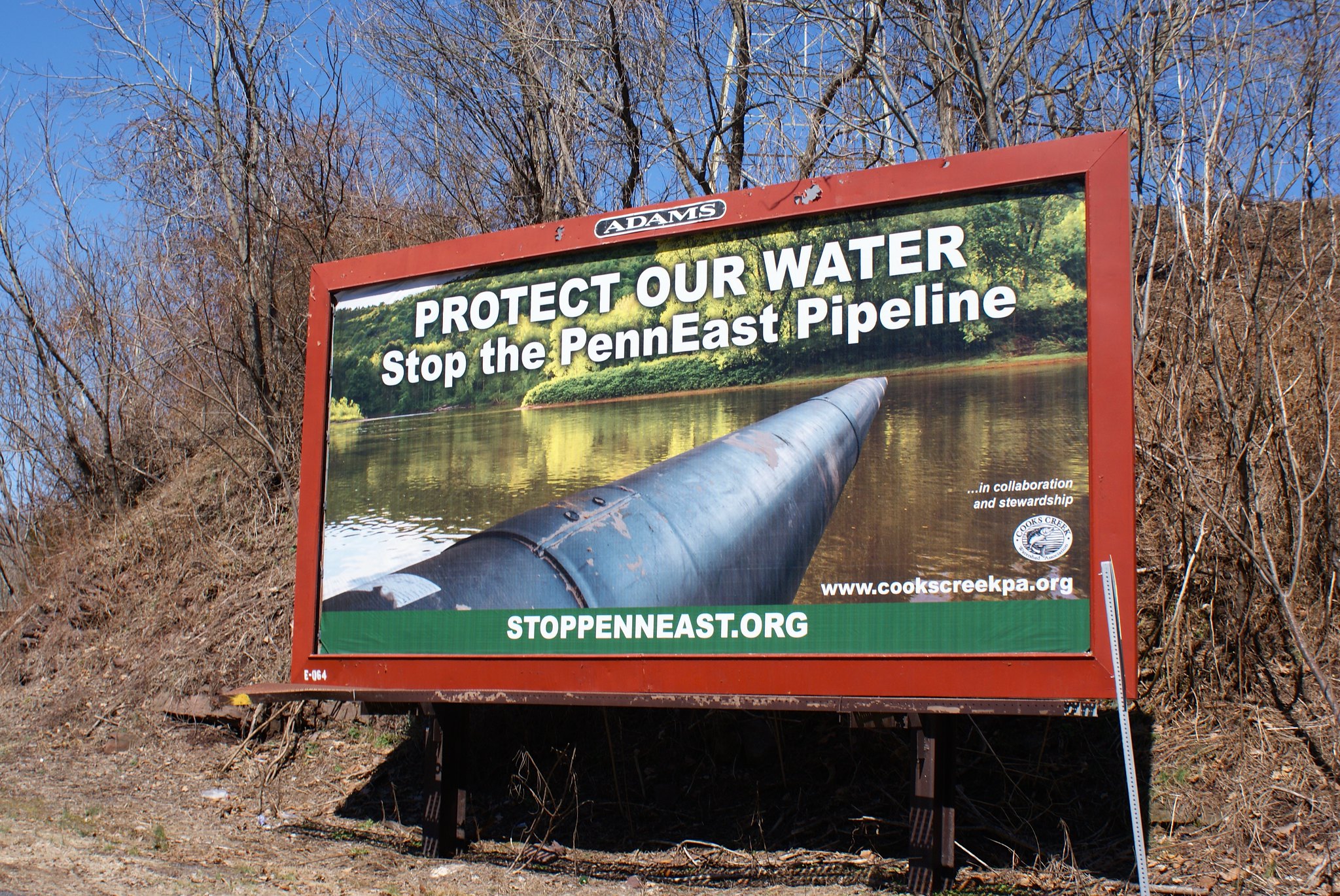
But I see new hope blooming in Pennsylvania, springing up in our midst right alongside the Spring daffodils. In an unprecedented some townships in the state have enacted formal resolutions against the pipeline. The Cooks Creek Watershed Association worked in concert with Concerned Citizens of Durham Townsphip against the Pipeline, Concerned Citizens Against the PennEast Pipeline of Williams Township, and stoppenneast.org to get a billboard against the pipeline installed on route 12.

Most recently, William G. Dohe, the Chairman of the Environmental Advisory Council of Easton, Pennsylvania, has filed a comment with the FERC declaring their organization is formally opposed to the pipeline. Mr. Dohe writes:

After careful review of information available to date, the Environmental Advisory Council of Easton, Pennsylvania wishes to record our opposition to the proposed PennEast Pipeline. We are concerned that the proposed Environmental Impact Statement (EIS) will be incomplete and not adequately weigh the direct economic benefit of PennEast Pipeline Company LLC to the risks and costs to the communities that will be forced to play its host.

The council then enumerates a list of specific areas of concern they want the FERC to force PennEast to address:

  • Carbon absorption.  “What is the total amount of carbon absorption lost due to the cutting of trees in the pipeline’s path? What is the net increase in GHGs attributable to this loss of vegetation?”.
  • Blast zone.  “What is the radius of likely property damage and loss of life, should the pipeline explode? This should be based on the total amount of gas under pressure proposed for the pipeline. A map should be prepared indicating what properties adjoining or in proximity to the pipeline will be subject to increased risk of property damage and bodily harm”.
  • Local usage.  “What percentage of the proposed pipeline gas will be delivered to the host communities versus the total amount of gas transported? How much gas will be delivered domestically versus shipped to overseas markets?
  • Global warming.  “How much does the gas transported by the pipeline contribute to GHGs (in metric tonnes per annum) and global warming?”
  • Leaks and other emissions.  “How much gas (and what kinds thereof) will be emitted (leaked or
    vented) from the pipeline, or its facilities along the route?
  • Construction runoff.  “During construction, what types of construction-related run-off is expected – including solids, silts, and chemicals – and what streams/rivers and aquifers will be affected?
  • Sinkholes.  “What impacts will the pipeline have on our karst soils, and specifically, what will be the increase in potential sinkholes from its construction?”
  • Historic site impact.  ” What historic resources will be affected by the pipeline? A map indicating all colonial era as well as pre-colonial era resources (such as tribal lands and burial areas) should be included.”
  • Audits.  “An independent audit of PennEast Pipeline Company’s “Economic Benefits Study” by Drexel should be conducted and actual long-term economic impacts be considered.”
  • Clean Air and Water Act regulations.  “A list of all Clean Air and Clean Water Act regulations from which the gas industry supplying the pipeline, as well as from which the pipeline itself are exempt, should also be provided so that the public can fully understand their short- and long-term- risks

Let’s hope that the FERC takes heed of this and similar submissions and forces PennEast to submit detailed studies and analysis of all of these topics.  On the issue of economic benefits in particular I would go even further than Mr. Dohe’s request for an audit of PennEast’s Drexel University study.  I would demand that an independent study be conducted, paid for by PennEast but selected by a neutral third party, which considers the true economic impact to our communities including all of the negative impacts the construction will entail in our region, including but not limited to loss of business due to construction near businesses, loss of tourism dollars in affected tourist destinations, funds spent by local, county, and state governments to study and respond to PennEast and FERC’s scoping process which could have been spent on more constructive projects, economic impact of traffic issues during construction, and permanent economic losses incurred by properties and landowners along the permanently cleared 50′ right of way.

The EAC’s submission is available below:

EAC FERC Submission
EAC FERC Submission Alternate Site


Issues with routing

Ned from Easton, PA writes to the FERC pointing out how bad the PennEast pipeline route is – and how easy it would be to fix it.

We are opposed to the PennEast pipeline project, and we call on the FERC to return a “no action” judgment for many unwise engineering decisions the company appears poised to make.

For example, how many interconnects does PennEast truly need with Transco/Columbia Gas pipeline in Williams and Lower Saucon Townships, Northampton County? The so-called Hellertown Lateral which hugs the northern side of Interstate 78’s west-bound lane from milepost 69.0 to its terminus in the existing city gate facility on the Hellertown- Raubsville Road, would, if built, provide an Interconnect between PennEast’s proposed system and Transco/Columbia Gas system. That being the case, why is a second Interconnect planned nearby at milepost 71.4 on land tract P9-7-13? Furthermore, with two Interconnects proposed within 4.5 miles of each other, why does PennEast need a separate right- of-way to connect those points (meaning the ROW as currently proposed to run from milepost 69.0 to 71.4)? Why not co-locate with the existing Transco/Columbia pipeline at least between these interconnection points which they plan to link? The second Transco Interconnect (the one proposed near milepost 71.4) is in remote, steeply sloped, inaccessible terrain more than 1500 feet from the nearest highway and, as proposed, will require construction of a dedicated access road to construct and to service it. The one at the western end of the Hellertown lateral is 10 ft from a major highway (the Hellertown-Raubsville Road) and has a truck- suitable entrance. Why can’t this Interconnect serve any gas cross-over needs between PennEast and Transco/Columbia?

Cannot FERC see that with poor judgments in planning such as this — and with the countless other engineering deficiencies, environmental challenges, and destruction of cultural/native peoples’ habitats as pointed out by numerous other commenters — that this entire PennEast Pipeline project is an unmitigated disaster? As noted above we urge a “no action” solution or, less preferably, a re-routing of the ROW from milepost 69 onto the Hellertown lateral with subsequent co-location on the Transco/Columbia ROW to reach tract P9-7-13 at presently designated milepost 71.4 and beyond.

See Ned’s submission below:

Ned from Easton PA – FERC Generated PDF

Ned from Easton PA – FERC Generated PDF Alternate Site

The Hexenkopf Slopes

Linda from Easton, PA wrote a submission to the FERC that focuses specifically on the Hexenkopf Slopes in PA:

My example is a land mass called Hexenkopf Slopes, a 1.6 billion year old (pre-Cambrian granitic) formation that houses not only Hexenkopf Rock (which is not directly threatened) but acres of forest, wetlands, and steep slopes surrounding it. This area provides a microcosm of a host of issues.
Forest impact: fragmentation of forest will occur when the pipeline, as projected, will move through Hexenkopf Slopes, a unique area cited by Lehigh Valley Planning Commission as an “important natural area.” In this one place (of the MANY places to which PA and NJ residents have alerted you) an estimated 3 Acres of trees will have to be cut (= oxygen for 54 people for a year); in addition, thanks to chemical herbicides in the trench, many nearby trees will die as well. Trees contribute heavily to reducing the carbon dioxide produced by human activity by converting it to the oxygen we breathe. Forests reduce storm water runoff and erosion as well as wind damage.

The steep slopes: the pipeline must drop from an escarpment on the Slopes down a 30% grade to private properties below, which are already subject to a runoff and erosion due to a prior pipeline (the Columbia gas line). With the removal of additional trees and the extreme disturbance of soil — drilling through rock, digging the pipeline route, and compaction of soil from heavy machinery – the erosion and runoff will be extremely exacerbated. During the storms of 2005, 2006, and 2012 runoff was so heavy it drove piles of loose stones from an access road off onto the very busy Raubsville Rd. and onto the farmland across Raubsville Rd. Trees intercept gallons and gallons of water, preventing flash flooding. Once this 100-foot wide track is compacted, runoff will not be able to be stopped. The effects will be cumulative and permanent. Our downhill neighbors’ residences will be horribly damaged.

To make matters worse, the Hexenkopf tracts through which the line passes have been preserved under Open Space programs with the County and the Township; the pipeline thus obviates the will of the people in preserving a natural climate-controlling carbon dioxide-to-oxygen mechanism. This is an unlawful taking by a private company for its own profit-making purposes and renders the land virtually worthless.

The forest is home to flora and fauna that will lose habitat because no tree is permitted to grow on the right of way, and studies show that invasive plants are the flora that manage to live on such disturbed soil. Native fauna do not eat the invasives. A study of the impact on native- dwelling and migratory birds and other wildlife needs to be made to assure they are not adversely impacted.

With the blasting that will be required to bring a 36” diameter pipe over a granite outcropping and down a 30% grade, there can be untold damage to groundwater/aquifers in the region, aquifers that feed local wells. A very large percentage of the population of Williams Township derives their water from wells or springs. And where would all the rocks from the blasting be placed? On areas where even those piles kill the protective vegetation that has grown there for thousands of years?

Wetlands on the edges of the Slopes suffer irremediable damage when heavy machines that need refueling or lubrication plow through the habitat of many microfauna, fauna, and birds and when additional space is taken for “temporary workspace.” Springs once destroyed cannot be resuscitated. Endangered species, such as the bog turtle, that lose habitat cannot be resuscitated either.

One of the headwaters of Fry’s Run, a High Quality-Cold Water Fishery and a Migratory Fishery and a tributary to the Delaware River, emanates from the northern base of Hexenkopf Slopes. Disturbance of this water source would further affect a stream that has achieved high quality status.
The cultural and historical remnants of early indigenous peoples have been treated by other speakers.

This one segment of the route encompasses a host of challenges which lead to the conclusion that this pipeline is totally inappropriate. We ask FERC to deny this application for a project that brings no benefit to the people of Williams Township but does inflict horrendous destruction that can never be remedied.

You’ll hear similar stories of other unique areas along the pipeline route that have their own problems – for example I highlighted a post earlier from the Washington Crossing Audubon Society about the threats to Baldpate Mountain, another unique preserved piece of land threatened by the pipeline.

Read Linda’s full submission below:

Linda from Easton PA – FERC Generated PDF

Linda from Easton PA – FERC Generated PDF Alternate Site

The importance of accurate maps

Laura from Easton PA has noted that PennEast has offered very confusing information about exactly where they’re considering to run the pipeline, and that the maps they’re using in particular are bewildering.

Maps of the proposed route provided by PennEast are STILL insufficient.
A neighbor told me yesterday that she JUST got a letter from PennEast as a stakeholder. The only map she’s seen does not show that the pipeline would go through her property.

Every map is different. Some are topographical, some are GIS, none show street names. I’m not sure how the public is supposed to interpret these maps. PennEast is not even trying to be cooperative. The intentionally mislead and confuse.

FERC should insist on consistent, readable maps from PennEast that actually show stakeholders and the public where they intend the pipeline to go. In addition to confusing people about their own properties, these maps make it impossible to make determinations for FERC’s upcoming environmental and historical scoping meetings.

I’ve thought precisely the same thing. The initial maps shown by PennEast were just topo maps with no easy way to tell how it correlated to people’s homes and places around them. They eventually gave a google-maps based map of the proposed corridor, but limited the zoom significantly so it was hard to tell exactly where it was.

Even the value of that map has been diminished because the PennEast inexplicably keeps alternating between the original November route and the January route. Depending when you go there you could get either route. And that’s a big deal because the routes are substantially different, particularly in New Jersey – the difference can be measured in miles.

Luckily the source google maps file (called a KMZ file) WAS available on their site, which I’ve linked to here:

January 2015 proposed pipeline route

Laura’s FERC submission is below for reference:

Laura from Easton PA – FERC Generated PDF

Laura from Easton PA – FERC Generated PDF Alternate Site

We’ve got sinkholes too!

It isn’t just earthquake and rain to worry about. Apparently Pennsylvania is serious sinkhole country to boot. Judith from Easton PA writes:

I am writing to register my strong opposition to the proposed PennEast pipeline. My main concern are the sinkholes that are in the area of
the pipeline,the destruction of the trees,and the run off down the mountain of hexenkopf and into our property and the farm across the street. This will affect Fry’s Run and THE Delaware River…
We have the Columbia Pipeline very close to us and know that you have already approved The LEIDY SOUTHEAST expansion project which will deliver gas from the same start point to the same end point…WHEN WILL THIS STOP???

An interesting thing to note here as well is her mention of the other pipelines already constructed and those in planning. From what I’ve read the FERC process does not consider pipeline projects all together to assess their aggregate impact on the area. Instead they study each one isolation as if none of the others exist.

This is glaring hole in the FERC process that makes the PennEast pipeline looks much better than it actually is in reality. Consider all the proposed pipelines simultaneously and you see that:

a) The supposed need for “more pipelines” goes down as you keep proposing…yet more pipelines.

b) The environmental impact is going to be much greater.

c) The percentage risk of catastrophe goes up with every pipeline built.

You can see Judith’s submission here:

Judith East PA – FERC Generated PDF

Judith East PA – FERC Generated PDF Alternate site

Runoff issues

When I lived in NYC I never gave any real thought to rain. It happened, I took an umbrella to work, and that was it. It wasn’t until I moved out to the country that I found out all complexities rain can bring to life – drainage ditches, runoff, water contamination, floods, you name it!

Jane in Easton PA focuses on this and other issues in her FERC submission.

Jane in Easton – FERC Generated PDF

Jane in Easton – FERC Generated PDF Alterate Site

I oppose the proposed Penn East pipeline specifically in the area of mile markers 71.5 to 72.5 due to first hand knowledge of runoff. In the area of mile marker 71.5 and the entire 400-foot area to be considered, the runoff has been so extensive as to cause a ditch along the road, which has to have stones added occasionally. Otherwise, there would be a very deep drop off immediately adjacent to the road. The removal of hundreds or thousands of trees just west of that area will most definitely add to this problem.

According to americanforests.org, a 5% increase in tree cover can offer a 2% decrease in runoff. It can only presumed that a 100% decrease in trees will drastically increase the runoff. Additionally, 1 tree is able to absorb 48 pounds of carbon dioxide and supply oxygen for 2 people, according to that same site. We need to keep every single tree that we possible can in order to absorb the pollution that we already have since the increase in pollution will be exacerbating the climate change.

It is then proposed to cross preserved farmland and through Fry’s Run, which is a High Quality Cold Water Fishery and Migratory Fishery. A Lancaster County farmer indicated in an article on Lancaster Online that his crops growth is stunted over the pipeline compared to an area 10 feet away from the right of way, and this is 24 years after that particular pipeline was installed. This preserved farmland will be subjected to that lose of productivity.