3D Flyover Video of PennEast Pipeline Route near Indian Lake, PA MP 21 to 13

This is part 20 of the 3D flyover video series of the PennEast routes – the final part!  In this installment, we look at the route near Indian Lake, PA from mile posts 21 to 13.

As always, the 400′ survey corridor is in smokey gray, the pipeline 50′ permanent easement line is in red, and the light blue areas are temporary construction zones. There is also a 100′ construction right of way not shown here.

I have also begun organizing these videos, they are all available under the “3D Flyover Videos” top navigation area.
 
Almost all of this part of the route is paralleling an existing cut through state game lands.  As with other “colocation” situations with PennEast, they are NOT within the existing right of way, but instead will be more than doubling the existing cut and expanding the right of way tremendously.

3D Fly0ver videos near Lake Harmony, PA MP 30 to MP 23

This is part 19 of the 3D flyover video series of the PennEast routes. In this installment, we look at the route near Lake Harmony, PA from mile posts 30 to 23.

As always, the 400′ survey corridor is in smokey gray, the pipeline 50′ permanent easement line is in red, and the light blue areas are temporary construction zones. There is also a 100′ construction right of way not shown here.

I have also begun organizing these videos, they are all available under the “3D Flyover Videos” top navigation area.
This whole section of the route, and extending north into the next areas all run through parks and state game lands.  You can see the reality from an overview shot from 40,800 feet here:
Screen Shot 2017-03-15 at 11.51.01 AM
This shows PennEast’s true nature.  Dirt cheap land acquisition costs coupled with enormous environmental impacts.

3D Flyover Video of PennEast Pipeline Route in Carbon County, PA MP 40 to 30

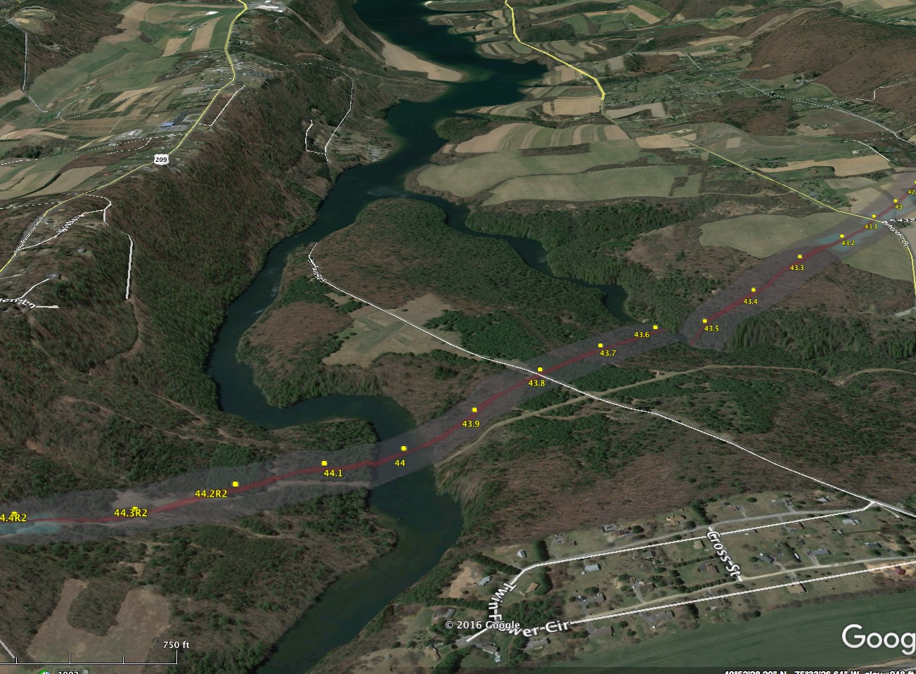
This is part 18 of the 3D flyover video series of the PennEast routes. In this installment, we look at the route in Carbon County between milepost 40 and 30.

As always, the 400′ survey corridor is in smokey gray, the pipeline 50′ permanent easement line is in red, and the light blue areas are temporary construction zones. There is also a 100′ construction right of way not shown here.

I have also begun organizing these videos, they are all available under the “3D Flyover Videos” top navigation area.
 
In this area, PennEast claims once again they are “colocated” in an existing utility corridor, and hence they are limiting impact.  We have a great example of that here.
For several miles, PennEast is co-located with what they call an “existing pipeline”.  Here’s what that existing impact looks like:
Screen Shot 2017-03-14 at 6.06.59 PM
That little trail there is the “co-location”.  Google Earth says the cut is about 6 feet wide (the little yellow line across the trail).  Yes, six feet.
Now here is the same spot with the PennEast plans overlaid.

Screen Shot 2017-03-14 at 6.07.37 PM

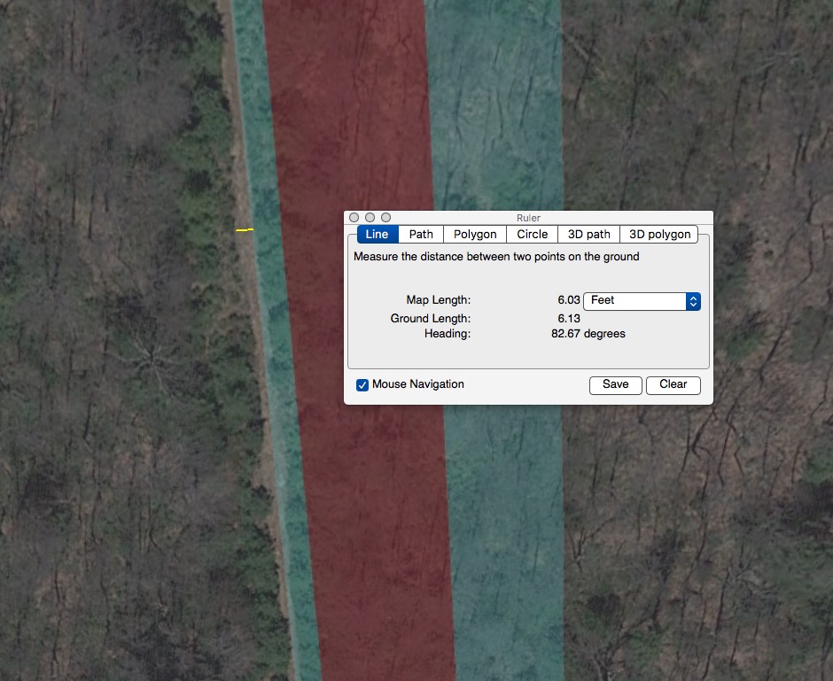
Here we see the same little 6 foot trail.  Then an extra 10′ temporary construction zone.  Then 50′ permanent right of way, and 50′ more on the right of that.
So our little 6′ cut becomes a 116′ cut.  That’s co-location for ya.
Are we maybe off our rockers?  Did PennEast maybe do the right thing and actually not include this area in its co-location tables?
Ha, of course they did!
Screen Shot 2017-03-14 at 6.46.47 PM
Here is PennEast’s submission to the Delaware River Basin Commission on co-location.  The area we’re highlighting is the 7.3 mile stretch highlighted in the table above.
When someone tell’s you PennEast is all-good because “it’s co-located with existing utility rights of way”, show ’em this post and many of the other fly over video posts.  Because in reality, it just ain’t so.

3D Flyover of PennEast Pipeline Route in Vicinity of Beltzville Lake in PA MP 49 to 40

This is part 17 of the 3D flyover video series of the PennEast routes. In this installment, we look at the route in the area of Beltzville Lake between mileposts 49 and 40.

As always, the 400′ survey corridor is in smokey gray, the pipeline 50′ permanent easement line is in red, and the light blue areas are temporary construction zones. There is also a 100′ construction right of way not shown here.

I have also begun organizing these videos, they are all available under the “3D Flyover Videos” top navigation area.
Starting at 0:30 in the video and for a large portion of this part of the route, we see extensive traversals of the pipeline up and down steep slopes.  Most of it not co-located at all.  So we have a very unfortunate roller coaster ride through some of the prettiest wooded and agricultural land in PA.
At 2:40 we enter the Beltzville Lake area.  PennEast is proposing another whopping 6,000′ long Horizontal Direction Drilling (HDD) attempt across both prongs of the lake formed by Wild Creek and Pohopoco Creek.  This is a massive drinking water reservoir system as well as recreational lake.  Here is a side view of the proposal there:

Screen Shot 2017-03-14 at 5.44.48 PM

And here is the HDD plans top-view:
Screen Shot 2017-03-14 at 5.48.52 PM
And the HDD plan vertical profile view (that shows how deep it goes).
 Screen Shot 2017-03-14 at 5.52.09 PM
 The HDD looks great, so long as it works.  As with the other sites in the area, if it does not work, PennEast will simply ask for a variance from PADEP to open-trench this area as well.  Given the dearth of survey data it generally has available, nobody knows if the HDD is actually a viable option here or not.

3D Flyover Video of PennEast Pipeline Route in vicinity of Chapman, PA MP 60 to 54

This is part 16 of the 3D flyover video series of the PennEast routes. In this installment, we look at the route in the vicinity of Chapman, PA between mileposts 60 and 54.

As always, the 400′ survey corridor is in smokey gray, the pipeline 50′ permanent easement line is in red, and the light blue areas are temporary construction zones. There is also a 100′ construction right of way not shown here.

 I have also begun organizing these videos, they are all available under the “3D Flyover Videos” top navigation area.

This portion of the route starts with a very unfortunate side-slope along the western end of a golf course.  This one runs for a half a mile . These side slope construction routes are killers for their potential for massive rain runoff, erosion, and downstream impacts.  The video flyover does not quite do it justice, I have an alternative viewpoint shown below:

Screen Shot 2017-03-12 at 8.18.21 PM

As you can see a large number of trees would be clear cut on this steep side slope.

The rest of the route hits mostly a number of farms, a clear case of targeting agriculture to lower PennEast’s land acquisition and construction costs.


3D Flyover Video of PennEast Pipeline Route in Vicinity of Bath, PA (MP 67 to 60)

This is part 15 of the 3D flyover video series of the PennEast routes. In this installment, we look at the route in the vicinity of Bath, PA between mileposts 67 and 60.

As always, the 400′ survey corridor is in smokey gray, the pipeline 50′ permanent easement line is in red, and the light blue areas are temporary construction zones. There is also a 100′ construction right of way not shown here.

 I have also begun organizing these videos, they are all available under the “3D Flyover Videos” top navigation area.
 
This section of the route consists of extensive agricultural impacts, with some light residential impacts as well.  It finishes up right at a golf course, with the pipeline centerline coming within 200′ of some of the greens.
I’ll be damned if I can see any co-location at all.