Anatomy of a Pipeline Explosion: Salem, PA

On Friday April 29th, 2016 at around 8:13 am, something horrible occurred in Salem, PA.  Workers at the Delmont Compressor station heard a massive explosion, and determined that one of their nearby Spectra Energy Texas Eastern natural gas transmission pipelines had been breached and exploded.  They began the shutdown process on the line, and reported the explosion to the National Response Center about an hour later.

The plume of gas and resulting smoke from the fire was so huge it showed up as a false weather front 40 miles long during the weather segment of the news.


In its wake, the explosion and resulting fire devastated the community. It left a hole 1,500 feet in diameter, and 40 acres of land were burned.  Here is a chopper view of the blast site at Gilli’s Lane and Route 819 in Salem Township, PA:

overheadshotsalempablasthc

The road was closed for days afterwards.  And here’s what the site used to look like, courtesy of Google Earth:

geoverheadsalempa

The approximate site of the breach is marked near the bottom-middle of the picture in red.

“House A”, 200′ from the breach, was completely destroyed and razed to the ground, along with all the trees surrounding it.

This is house “A” after the breach:

KEITH SRAKOCIC / AP

House “B” was 800′ away from the breach.  It was so hot that the vinyl siding melted from the garage:

KEITH SRAKOCIC / AP

A 26 year old man was admitted to the hospital with 3rd degree burns over 75% of his body.  Trees and telephone poles thousands of feet from the explosion were charred and smoking  hours after the incident occurred.

KEITH SRAKOCIC / AP

As with many blasts, the blast zone and heat focus was asymmetrical due to the terrain and the exact nature of the blast.  In this case, the pipeline was in a bit of a valley.  Geography and prevailing winds pushed the heat towards House A and House B.

salempa3dview


Investigation

The Pipeline Hazardous Materials Safety Administration (PHMSA), who is charged with regulating pipeline safety, performed a preliminary inspection and determined that it had “identified evidence of corrosion along two of the circumferential welds: one at the point of failure and another excavated after PHMSA’s response to the Failure Site. The pattern of corrosion indicates a possible flaw in the coating material applied to girth weld joints following construction welding procedures in the field at that time”.

A spokesman for the pipeline company, Spectra Energy, stated that an inspection in 2012 “revealed no areas requiring repair or remediation before the next inspection”. Records were checked for seismic activity or other construction that might have impinged on the pipeline, but no definitive conclusion was reached.

Fast forward five months, to September 2016, and clearer picture emerges. As it turns out, Spectra’s comment immediately after the blast was very carefully worded. While they may not have found any areas “requiring repair”, they did in fact find corrosion at this exact site.

And not just a tiny bit.

In fact, Spectra admitted that a routine inspection in 2012 showed a 30% decrease in the thickness of the pipeline wall precisely in the location where the pipeline blew.

Let that sink in. Thirty. Percent.

Despite this, a Spectra Energy spokesperson was quoted said this about the “It was very small. It was smaller than any threshold we would have been required to investigate”.

What this means is that Spectra believed that 30% decrease in pipeline thickness was no cause for alarm, and they let it sit there un-inspected for another 4 years until the explosion happened.

They remain mystified as to why it occurred. Maybe the gas was too hot, with the breach happening near the compressor station. Maybe the tape used to join welds was bad. Or maybe it was “something else” local to that site.

The pipeline company shrugs and apologizes profusely to the family of the man who was burned over 75% of his body. There are “no words” for he went through, they say, and in the next sentence they go onto explain that their models and “the science” indicated that what happened could not have happened.

I believe strongly in Science, being an engineer by profession for nearly 30 years. But not in “Science” where arbitrary numbers and models are used as an excuse for a company to cut corners.


Comparison to PennEast

All this information is particularly chilling when you compare and contrast the Spectra Texas Eastern pipeline with the PennEast one.

The Texas Eastern line was 30″ in diameter, and was most likely considered a “class 1” or “class 2″ location in terms of safety (this is determined by how many residences or businesses are close to the pipeline).  At the time of the blast it was operating at about 1,039 pounds per square inch (psi), with a maximum allowable pressure of 1,050 psi.

This is a bit smaller than PennEast and at lower pressure (PennEast is 36” in diameter with a maximum pressure of 1480 psi).  Hence a breach of PennEast would result in a larger area of devastation than in these pictures.

As mentioned above, the Spectra Pipeline lost 30% of its thickness.  What if something similar happened with PennEast?  Most of our areas are classified as Class 1 or Class 2 like the explosion in Salem, PA, so we have apples to apples in that regard.

We also have the thicknesses for PennEast from a previous blog post on that topic.  Assuming Class 2 pipe, that’s 0.634″ thick (for contrast:  class 4 pipe, the safest, would 0.951″).

A loss of 30% of thickness would drop the pipe from that down to only .444 inches. For reference, the safety margin for the pipeline would be eliminated entirely at a thickness of .38″.  So the equivalent situation for PennEast would be an inspection from 2012 allowing a pipeline to go on with only 0.06″ safety margin in the pipeline thickness.

Why do we care about this?  Because FERC is allowing PennEast to run PennEast a LOT closes to houses than the case of the Salem blast.  Remember, in the Salem blast a house 200′ feet away was burned down by a smaller pipeline with less pressure than PennEast.

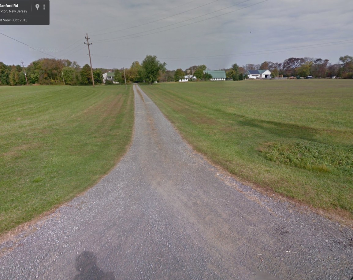
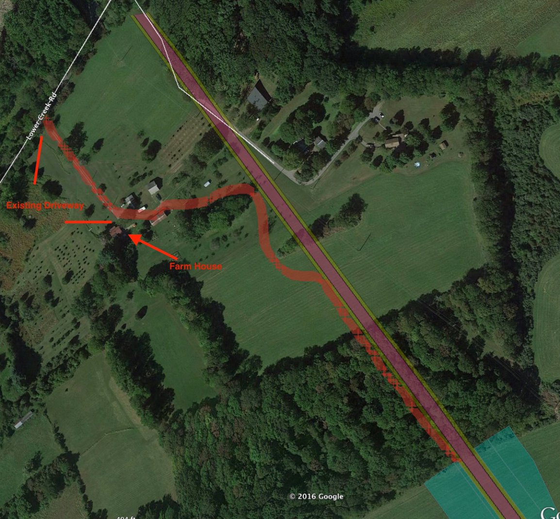
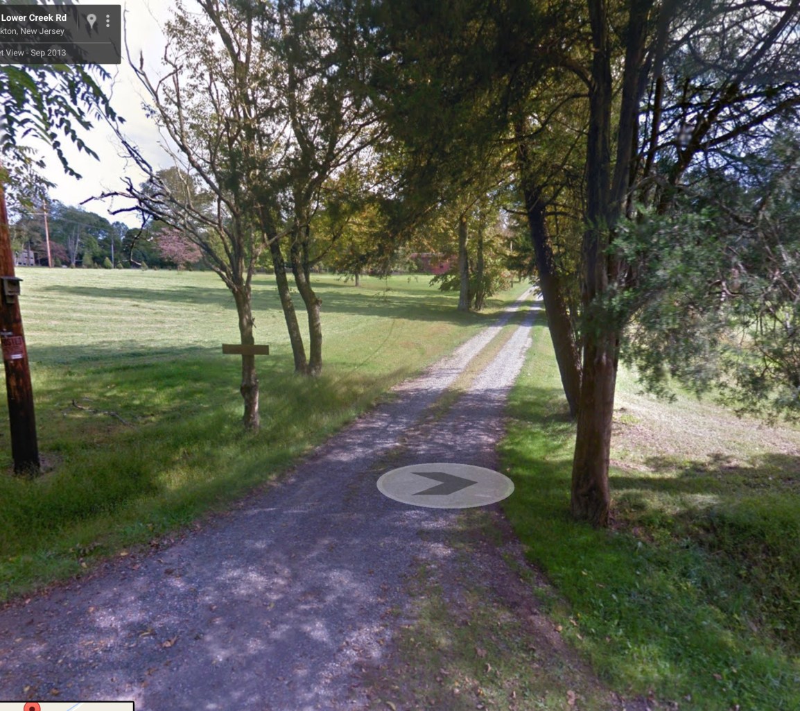
Here’s the Kelly-Mackey farm on Sanford Road.   The HDD tunnel entrance for the pipeline will be about 65′ from their farm house.

sanfordroadgoogleearthview

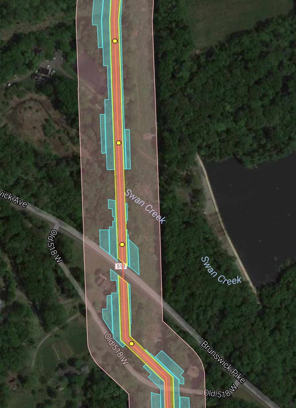
Here is the pipeline construction near Old Route 518 in West Amwell.  The pipeline will be 100′ from one house, and 50′ from another.

changeoldroute518

The Lower Mall at Route 33 in PA:

chnagepalowesshoppinghddsite

These are just a few of many. In all, the PennEast Draft Environmental Impact Statement identified many  structures and houses that would be a mere 50′ from the pipeline construction.  Hundreds more are within the same 200′ zone as the “House A” that was burned to the ground by a smaller pipeline under less pressure.

This is why people worry, and this is why people protest.  Pipeline companies ignore signs of corrosion and serious issues, and wait years to reinspect known areas that have problems.  They deliberately build pipelines near homes and schools and commercial centers, and then just shrug and write off the loss if an explosion happens.

FERC needs to wake up and disallow this sort of thing.  Ignorance was acceptable in the 1950’s when we knew so little about…well, most everything.  But this is 2016.  We know pipelines corrode and that often the pipeline companies have no idea why.  We know they explode.  So why on Earth are you still allowing them to endanger our lives in this way?


overheadshotsalempablast
KEITH SRAKOCIC / AP


Running these sites is getting expensive.  If you want to help out with the hosting and other costs of running thecostofthepipeline.com along with pipeinfo.org, then please take a look at the donate page.  Thanks!

Donate with PayPal

The Cost of Horizontal Directional Drilling

Horizontal Directional Drilling, or HDD, is sold by pipeline companies as a panacea for a host of problems with pipeline routes.  Usually natural gas pipelines are built by trenching down in the ground 6-9 feet deep, then covering up the pipe once it’s installed.  HDD involves drilling a bore hole under ground instead, and then either pulling or pushing the pipe through that.  The upside is there’s no trench and no need to clear cut.  The downside is that it’s often very difficult to do, its success depends upon geology, and when it fails it can be very, very bad indeed.  Plus, there is a very large construction impact at the entry/exit points where the HDD enters/exits the ground.

One such spot is Carla Kelly-Mackey’s farm on Sanford Road in Delaware Township.  Carla is a member of HALT PennEast, and has been staunchly against the project from the beginning.  As route change after route change has come it has danced slightly all around her farm.  With the most recent route change, her front door is now proposed to be home to an HDD construction pad.

Here are the latest plans for her farm:

sanfordroadkelly-mackeyfarmplans

As you can see, they plan on using her driveway as a construction access road, and then staging the HDD site across her driveway and in her front yard.  Here’s what it looks like in Google Earth:

sanfordroadgoogleearthview

I used the Google Earth measuring tool to check the distance from the construction zone to her house – as you can see it’s less than 50 feet!

The “road” they’ll be using:

sanfordroaddriveway

Now what will all this HDD construction look like?  We don’t know for sure yet, but here’s a sample of a 36″ pipe being HDD’d down in Florida:

In that case of that project, the construction crew worked 24/7 to get the job done (it was blocking a freeway express ramp). Working non stop day and night it took 10 days to complete the HDD installation. They used something called a “300-ton Herrenknecht Pipe Thruster” to get the job done.  Hopefully PennEast will not be banging on that pipe in three in the morning, so who knows how long this job will take?  According to the HDD plans they will be boring and pushing/pulling for around half a mile…..

Imagine THAT in your driveway and 50 feet from your front door.


Running these sites is getting expensive.  If you want to help out with the hosting and other costs of running thecostofthepipeline.com along with pipeinfo.org, then please take a look at the donate page.  Thanks!

Donate with PayPal

Another Disastrous Access Road

Earlier in the week the disastrous access road proposed to connect to Stymiest Street in West Amwell was described.  There PennEast proposed to build a temporary construction road charging straight up the mountain and cause severe runoff and erosion issues.  Not to mention it was connecting to a tiny one lane gravel road that in turns connects to tiny Quarry Street in Lambertville.

But that isn’t the worst one proposed.  Oh no, there are more!  Over in Delaware Township, the plans have changed around Lower Creek Road from open trenching to a Horizontal Directional Drilling “solution”.  These are sold as being much better for the environment (a claim many dispute, but that’s the topic of another story).  In this case, the HDD proposal means they need large staging sites on either side of where they intend to drill.  South of Lower Creek Road they propose a staging site on a neighboring farm of T.C. and Joe Buchanan.  And to get there, they propose to use their driveway as a construction road.  Yes, that’s right.  Here are the plans:

roadplanslowercreekroad

That dark gray wavvy line is the proposed road. You can see it snaking between the farm houses and buildings on the farm, then running along the pipeline route and terminating at the HDD staging site.

Here’s a google earth map showing the same area:

lowercreekroadaccessroad

As you can see from the plans and the pictures, what they are proposing is to go up T.C. and Joe’s existing gravel driveway.  Here’s what that driveway looks like:

lowercreekroaddriveway

This is a typical country farm one-lane driveway.  They’re going to expand this to be 50′ wide, taking out trees on both sides.  Look back at the plans, and you’ll see it running within about 10′ of their farm house.  It runs right across their fields, making them useless.

The HDD itself goes down about 80′ – right at the level of everyone’s wells in the area.  TC tells me it’s going right through some wells.

Imagine having machinery like this lumbering 10′ away from your house:

As a final insult, all this information came out AFTER the DEIS was issued.  So TC and Joe don’t even have an opportunity to comment or object in the official process.


Running these sites is getting expensive.  If you want to help out with the hosting and other costs of running thecostofthepipeline.com along with pipeinfo.org, then please take a look at the donate page.  Thanks!

Donate with PayPal

Improved Map for September 2016 Route Changes

Every time PennEast releases a set of maps, they do it differently.  Every. Single. Time.  The result is that we see a very inconsistent view of the route over time, and it is frankly frustrating as hell.

The map I published a few days ago was the first to include construction work spaces, and also the actual Right-of-Way.  In that respect it was a big improvement.  But it lacked the center line, mile markers, and the 400′ “study corridor” mandated by FERC.

Fortunately (?), PennEast has been sharing different versions of their maps with different parties. In particular, the general public was given one set of maps (the one I distributed), and then municipalities were given a different map.  I was able to combine the best features of both into a new map that is greatly improved.  The links here and http://pipeinfo.org have been updated with the new map.  Here it is:

https://www.google.com/maps/d/viewer?mid=1HseJh7rKferTARPMVWrOQvIIvb8

The map features include:

  • All features are made semi-transparent so you can see what’s underneath them
  • Pipeline centerline
  • Permanent Right-of-Way
  • Mile markers (clickable yellow dots)
  • Construction areas (cyan)
  • 400′ study corridor (shaded pink)
  • Permanent above ground features (compressor stations, launchers, etc)

A sample is shown below:

compositemapsample


Running these sites is getting expensive.  If you want to help out with the hosting and other costs of running thecostofthepipeline.com along with pipeinfo.org, then please take a look at the donate page.  Thanks!

Donate with PayPal

Map: Baldpate Access Road

Yet another access road planned for PennEast.  This one goes from Pleasant Valley Road onto their site on Baldpate Mountain.

baldpateaccessroad

The access road is the dark grey path on the upper left of the map snaking up to the pipeline construction area.

Note that the picked one of the steepest possible slopes for this road.  Here’s approximately where it is on Google Earth with 3D terrain turned on:

baldpateaccessroadgoogleearth

As you can see, the proposed access road goes up the side of the mountain and then back down to get to the pipeline construction area.  This is the second steepest slope on Baldpate that I can see, and PennEast seems to have made it deliberately as awful as possible.

And this is on top of the existing impacts we knew about.  Here’s a direct overhead shot of the site:

baldpateoverheadimpacts

You can see all of those construction work spaces digging into the existing old growth trees, and then the helpful access road to make it even worse.

As a final note, I’ll show what Fairfax Hutter dubbed the Baldpate “Mohawk”.  The so called “colocation”, that really isn’t.  In this case, the pipeline has to be sited far enough from the high voltage lines that the construction is in an entirely new corridor on Baldpate, with a thin area of trees between the power lines and PennEast e.g. the Mohawk.

baldpatemohawk

My son might think this is cool, but pretty much everyone else is going to hate this.