Phil Murphy: “I am against it in any incarnation”

NJ Democratic Gubernatorial candidate Phil Murphy was at the Acme Screening Room in Lambertville this afternoon in a Meet’n’Greet to talk to voters and tell people about his views.

Towards the end of the session, Lorraine Crowne asked this question (note: this is paraphrased):

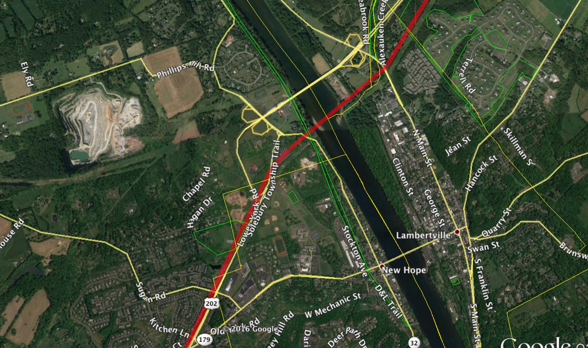
“I live in the Highlands area, and as you know there are many restrictions to development there because of the Highlands Act.  But now you have the PennEast pipeline proposed to go right through it.  What is your stance on the PennEast project?”.

Mr. Murphy’s response was unequivocal and direct.  He said that he was against the pipeline.  That in his analysis, there was no business case for the project.  That the environmental damage would be unacceptable.  And to answer a followup from Lorraine, he wasn’t just against one route in particular, but he was against the project in any variation or incarnation.

A bunch of HALT PennEast and Citizens Against the Pipeline (CAP) members were able to get a picture with Mr. Murphy and our signs, see below.

philmurphystoppenneast
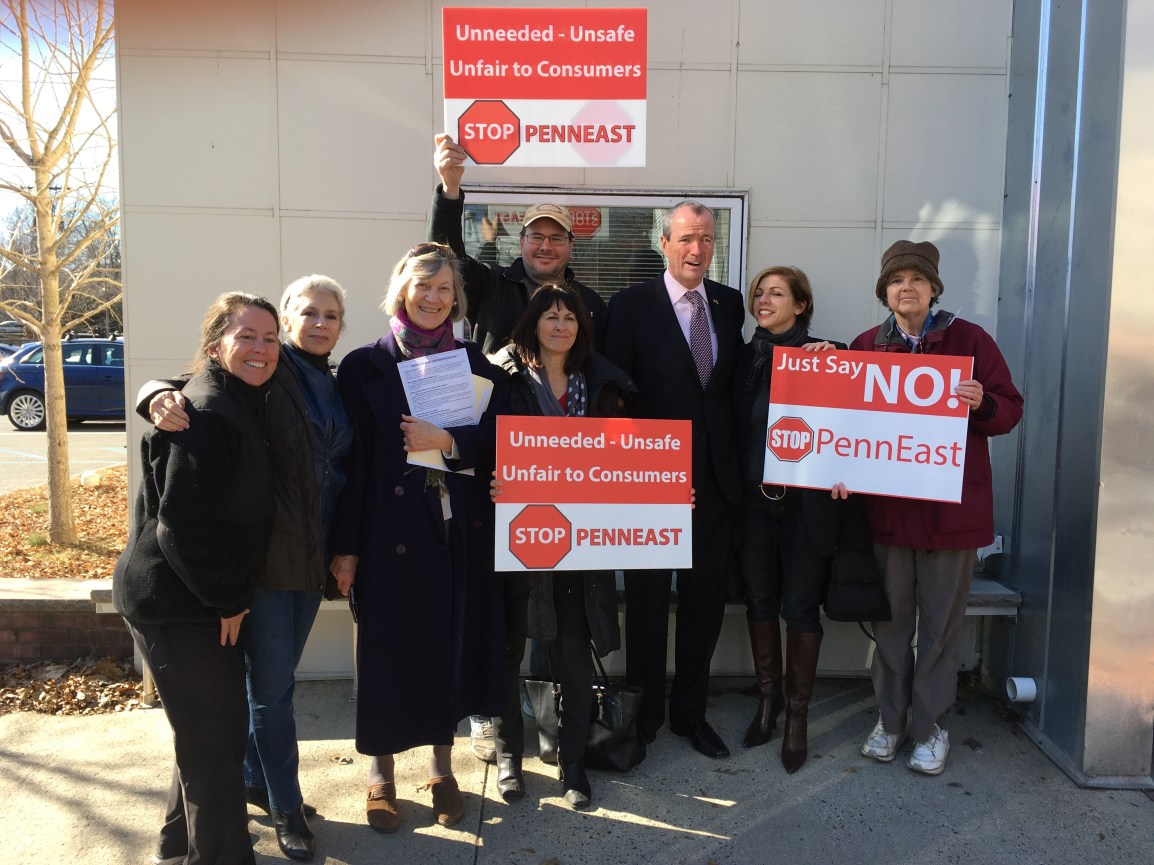
In all, we got representatives from Delaware Township CAP, Lambertville CAP, Hopewell Township CAP, West Amwell CAP (that goober in the middle holding up the sign over his head) and HALT PennEast.

One of his staffers also indicated that Mr. Murphy would de-politicize the NJDEP and return it into a truly independent agency dedicated to protecting the State’s environment.

In talking to the crowd Mr. Murphy indicated he was a candidate with his heart in the right place who intended to do good things for the State – but that we shouldn’t take his word for it, and we should hold him accountable that his actions in the future match these words today.  We will certainly do that, and if Mr. Murphy is elected we will remind him (repeatedly!) of the promises of himself and his staffers today.


Here’s why people find PennEast incompetent

PennEast representatives sometimes seem almost mortally exasperated in dealing with the press and general public.  They are constantly barraged with accusations of the company being bunglers, incompetents, deliberating misleading, and just plain not very good at their jobs.  And PennEast reps can’t understand why this is.  Why all the hate, people?

Well, tonight I was looking in some more detail into those IBA Avoidance routes.  In particular I was double checking the alignment, which I know is off a bit here and there.  I do that by changing the transparency of the PennEast map image back and forth from fully transparent to fully opaque, and seeing how the underlying Google map matches up to the PennEast map.

And in doing so, I remembered why it’s so hard to get the maps to line up exactly.  The PennEast map is the most ridiculous map artifact I’ve ever dealt with.  Here’s what I mean.  Here is a closeup of the PennEast version of the “IBA Avoidance” area going around Baldpate mountain.

Map A – PennEast’s Extraordinarly useful Map

screen-shot-2016-12-08-at-7-22-28-pm

And now here’s the same thing in Google Earth:

Map B – Google Earth Version of the same location

screen-shot-2016-12-08-at-7-10-10-pm

Yes, these two maps are showing the same thing!  The blob you see on the left on PennEast’s map is in fact a Trap Rock quarry.  The black line is the Delaware River.  The beige-ish blob you see to the right of the Delaware?  That’s Lambertville City!  The beige line you see above the pipeline route?  That’s the Route 202 bridge.

Oh yeah, and Google Earth has little things like city markers and road names!

If you look really closely you actually see many features are entirely missing from the PennEast map, such as several housing developments.  It makes you wonder just how old the PennEast base map really is.

This is a microcosm of what people who deal with PennEast see every day.  Mind-numbingly bad and useless information and materials.

Pat Kornick, you wonder why people hate your company so much?  Look at “Map A” and wonder no more.

All of the PennEast Routes in one map

screen-shot-2016-12-07-at-4-56-11-pm

Welcome to the “All Possible Routes” PennEast map:

https://drive.google.com/open?id=1D3K52CZ7YlojYulRNHdHpei_D-Q&usp=sharing

To help people make sense out of the craziness that is PennEast, I’ve put together a map that contains a number of route changes into one place.  This map shows all of the various major PennEast re-routes, including:

  • 2014 original Route
  • Jan 2015 MAJOR Route Change
  • March 2015 Route Changes
  • September 2015 Application Route
  • February 2016 Route Changes
  • September 2016 Route Changes
  • “IBA Avoidance” proposals from PennEast

Please note that the IBA avoidance maps are only approximate, they are based on manually aligning the PennEast images in Google Earth via image overlay.  They may be off by up to a 150′ or so, so take them with a grain of salt.  The other maps are all directly sourced from PennEast.

https://drive.google.com/open?id=1D3K52CZ7YlojYulRNHdHpei_D-Q&usp=sharing


Running these sites is getting expensive!  Please help defer our costs and pop over to the donate page, or use the donate button below.  Thanks!

Donate with PayPal

Those crazy Important Bird Area “avoidance” routes

screen-shot-2016-11-28-at-7-24-49-pm
As part of PennEast’s most recent submissions to FERC, they were asked to look at re-routes to avoid Important Bird Areas (IBA). This because they are severely impacting several.
 
Their answer? The maps below. The blunt lines in blue are the “alternative” possible route that would avoid IBAs. Except these alternatives are clearly crazy. They add miles to the route and are completely unsurveyed.
 
These are NOT any sort of official route, and PennEast is saying they are not interested in developing them, but nonetheless these are their possible response routes if they are forced to avoid IBAs.
 
The places to look:
 
Hickory Run State Park (PA) – Alternate runs to the east of the park through a housing development.
 
Holland NJ area (NJ) – Alternate avoids Holland almost all together, crosses more of PA with a stab upwards to connect to the Gilbert plant, and then crosses the Delaware at another point to continue into NJ. Yes, two crossings of the Delaware for this.
 
Frenchtown (NJ) – Route moves closer to Frenchtown in the vicinity of Horseshoe Bend Road.
 
West Amwell (NJ) – Route misses West Amwell and Baldpate Mountain almost entirely. By heading out West at Route 202, over the Delaware and then going South West 8.4 miles into PA. Then turning around and ultimately crossing the Delaware again between the I95 Bridge and the Washington Crossing Bridge
Many people think these proposals are being made to make the current route look good.  Others think maybe PennEast is trying to avoid more of NJ.  It’s tough to say, but no matter how you look at it these alternate routes are very, very bad options.  Warn people you know in these areas and get them involved!  They can still comment before the Dec 5th deadline.
 
Map link below:

Running these sites is getting expensive!  Please help defer our costs and pop over to the donate page, or use the donate button below.  Thanks!

Donate with PayPal

You can still intervene against PennEast, and right now it’s extra easy to do

intrervene

Many people are confused by the FERC intervention process, and the various time windows when you are considered “timely”, and when you’re considered late (technically known as intervening “out-of-time”).

What is intervening in a FERC matter?  What it means is that you are formally declaring yourself as an interested party.  And by doing so, you are forcing FERC to respond to any issues you bring up.  Plus, you can be party in any suits or motions against the project before FERC.  Note the intervening is not the same as commenting – intervening defines your status are someone formally declaring yourself as wanting to be involved.  Comments are independent of that, and you can comment as many times as you like.  You only need to intervene once in the proceeding, so if you’ve already intervened you’re all good, and keep focusing on sending FERC comments!

If you’re not an intervenor, FERC has no obligation to listen to you or to respond to, and you may not be party to any motions against it.

On the “timely” vs. out-of-time stuff, there are only limited times when FERC considers you intervening in a timely manner.  If you intervene out side of these windows, FERC may reject your intervention out of hand as being obstructionist and/or irrelevant to the proceedings.  So you want to be a “timely” intervenor if at all possible.

The good news is that right now we happen to be in such a window!  FERC has a rule that states that any filing to intervene during a DEIS  comment period is automatically considered “timely”:

https://www.law.cornell.edu/cfr/text/18/380.10

Any person who files a motion to intervene on the basis of a draft environmental impact statement will be deemed to have filed a timely motion, in accordance with § 385.214, as long as the motion is filed within the comment period for the draft environmental impact statement.

Since FERC has added a 30 day comment period on the Draft EIS (based on the September 23rd route changes), this means people can file a timely intervention with FERC.

So if you file by December 5th, you will be automatically accepted as an intervenor on PennEast.

There are many reasons to intervene in the proceeding, and no downsides at all.  Some things to note:

  • FERC’s own regulations say they must answer every issue pointed out by an intervenor.  If you are not an intervenor, there is no requirement that they answer you.
  • Higher intervenor counts tell the federal government the level of interest and opposition to the project
  • Timely intervening  is very simple.  See the link below.
  • You don’t need a lawyer and it’s free
  • Adding yourself to the growing list of intervenors sends a powerful message to our politicians, agencies such as NJDEP and the Delaware River Basin Commission, and others.
Read more about intervention and how to do it here:

http://www.pipeinfo.org/intervene

We also have a sample document you can use to intervene anytime by December 5th.

Sample Intervening Document – use by December 5th, 2016

Be sure to replace your name and address everywhere relevant in the document (bolded).

NOTE: If you miss the December 5th, deadline, we go back to any requested interventions being “out-of-time”.  Those are more complex and may be rejected by FERC, so it’s in your best interest to get this done by the 5th!

If you do need to intervene out of time please contact us at thecostofthepipeline@gmail.com and we’ll get you instructions in how to do so.


Running these sites is getting expensive!  Please help defer our costs and pop over to the donate page, or use the donate button below.  Thanks!

Donate with PayPal

Open cutting through our roads

So PennEast released part of their “traffic plan” today as part of their big data dump to FERC.  It’s not so much of a plan as it is a list of what roads they’re crossing, and whether they’re going to bore under them, HDD under them, or simply open trench cut through them.

Originally indications were that PennEast would bore or HDD under every asphalt road, at least in the NJ side.

Well, they changed their minds.  The following is the list of roads where they intend to Open Cut trench.

NJ

Hopewell:
Blackwell Road (twice)
Lawrenceville Pennington Road/Rte 632
Reed Road
Pennington Titusville Road
Goat Hill Road (Twice!)

West Amwell
Hewitt Road
Old Route 518 W

Delaware/Kingwood Area:
Phillips Road
Dogwood Drive
Church Road

Holland/Alexandria Area:
Phillips Road
Gilbert Plant Road

PA

Sherers Hill Road
Spring Hill Road
Durham Road
Raubsville Road
Hexenkoph Road
Buttermilk Road

Birkland Place
William Penn Highway
Church Road
Green Pond Road

Hecktown Road

Monocacy Drive/State Route 987
Hatch Gravel Rd T496
Glase Road
Biegley Road

State Game Land Access Road MP 51.0R2
Lower Smith Gap Road
Whitetail Ln

Little Gap Road
Spruce Road
Beers Ln
Long Fenc Rd
Spruce Hollow Rd

Lovitt Road/T527
Towamansing Rd
Redwood Drive
Balsam Drive

Shades Glen Road

Election Road
Cody Ln

Ridgewood Road
Union Street
Shulde Ln
North Ridge
Bunker Hill Road
Carveton Road
Gypsy Ln


Running these sites is getting expensive!  Please help defer our costs and pop over to the donate page, or use the donate button below.  Thanks!

Donate with PayPal